How to Navigate to St. Mark’s Basilica by Foot Without Getting Lost
Venice is a city designed entirely for the pedestrian. With no cars, no bicycles, and an intricate web of over 400 bridges spanning 150 canals, walking is not just a choice—it is an art form. At the geographic and cultural heart of this floating labyrinth sits St. Mark’s Basilica (Basilica di San Marco), its golden mosaics and Byzantine domes serving as the ultimate destination for millions of travelers.
While catching a vaporettos (water bus) is convenient, walking through Venice’s historical sestieri (districts) reveals hidden courtyards, ancient architectural anomalies, and local neighborhood life that you completely miss from the water.
Starting Point
Distance
Est. Time
Santa Lucia
2.3 km
35–45 min
Piazzale Roma
2.5 km
40–50 min
Rialto
0.65 km
10–15 min
Accademia
1.2 km
15–20 min
This comprehensive guide details the absolute best walking routes to St. Mark’s Basilica from Venice’s primary entry points and major hubs.
Before setting out, it is essential to understand how Venice’s street system functions. The city does not follow a standard grid, and GPS signals frequently drop or lag due to the narrowness of the alleyways (calli).
Keep these basic navigation principles in mind as you walk:
Follow the Yellow Signs: Painted high on the corners of buildings throughout the city are iconic yellow directional signs. Look for “Per San Marco” (To St. Mark’s) and “Per Rialto” (To the Rialto Bridge). When digital maps fail, these historic trail markers are your most reliable resource.
Understand the Vocabulary: You won’t find many “streets” in Venice. Instead, you will walk along a calle (standard alley), a salizzada (historically paved main street), a fondamenta (walkway running alongside a canal), or a ruga (a street lined with shops). A square is a campo, with the sole exception of Piazza San Marco itself.
Keep to the Right: Venetian alleys can become incredibly congested. To maintain traffic flow, always walk on the right side of the calle and pull over to the side if you need to stop to look at a map or take a photograph.
Step Counter Expectations: Venice requires unexpected physical exertion. A direct route that looks like a 20-minute walk on a map often takes 30 to 45 minutes due to the crowds, dead ends, and the constant need to ascend and descend stepped bridges.
Route 1: From Santa Lucia Railway Station (Stazione FS)
For most travelers arriving from mainland Italy, the journey begins at the Stazione di Venezia Santa Lucia. Walking from the station to St. Mark’s Basilica takes you completely across the upper loop of the Grand Canal, transitioning from the bustling transport hub to the historic heart of the republic.
Distance: Approximately 2.3 kilometers (1.4 miles)
Average Walking Time: 35 to 45 minutes at a steady pace
Difficulty Level: Moderate (frequent bridges and high foot traffic)
Primary Sestieri Crossed: Cannaregio, San Polo, and San Marco
Step-by-Step Pedestrian Directions
Exit onto the Station Promenade: Step out of the terminal doors and descend the wide stone steps. Turn immediately left onto the Rio Terrà Lista di Spagna. This is a wide, lively pedestrian thoroughfare lined with hotels, cafes, and shops.
Cross the Ponte delle Guglie: Continue straight along the Lista di Spagna until you hit the Ponte delle Guglie, a large 16th-century stone bridge crossing the Cannaregio Canal. Cross it and continue straight down Rio Terrà San Leonardo.
Follow the Strada Nova: The path naturally transitions into the Strada Nova, one of the widest and straightest walkways in Venice, constructed in the 19th century. Follow this long avenue through the heart of Cannaregio for roughly 10–15 minutes.
Veer Towards Campo Apostoli: As the Strada Nova terminates, follow the natural bend of the walkway to the right, passing through Campo dei Santi Apostoli. Look for the yellow signs pointing toward “Rialto.”
Cross the Rialto Bridge: From Campo Apostoli, navigate south along Salizzada San Giovanni Crisostomo, which leads you directly to the foot of the Rialto Bridge (Ponte di Rialto). Climb the central staircase of this architectural marvel to cross the Grand Canal.
Navigate the Mercerie to San Marco: Once on the other side of the bridge, you enter the San Marco district. Pass through the small square (Campo San Bartolomeo) and look for the entrance to the Mercerie (specifically Mercerie 2 Aprile). This series of historic commercial alleys winds directly south, eventually dumping you out through a dramatic archway underneath the iconic Clock Tower into Piazza San Marco.
Route 2: From Piazzale Roma (The Car & Bus Terminal)
Piazzale Roma is the final destination for land-based vehicles, including airport buses, taxis, and tramways. If you arrive by road, this is where your pedestrian journey begins.
Distance: Approximately 2.5 kilometers (1.55 miles)
Average Walking Time: 40 to 50 minutes
Difficulty Level: Moderate to High (winding paths through the interior residential quarters)
Primary Sestieri Crossed: Santa Croce, San Polo, and San Marco
Step-by-Step Pedestrian Directions
Cross the Ponte della Costituzione (Optional): If you prefer to mimic the train station route, cross the modern glass bridge (Ponte della Costituzione) over the Grand Canal to the front of the railway station and follow Route 1. Otherwise, take the more classic, atmospheric route through the interior of Santa Croce detailed below.
Head Toward Campo Minotto: From the eastern edge of Piazzale Roma, walk past the vaporetto ticket booths and head southeast over the stone steps of the Ponte del Forno into the quiet streets of the Santa Croce neighborhood. Walk along Fondamenta Minotto.
Navigate to Campo San Rocco and Frari: Follow the yellow signs directing traffic toward “Rialto” through a succession of narrow alleys until you arrive at the open space of Campo San Rocco, home to the spectacular Scuola Grande di San Rocco. Directly adjacent to it sits the towering Gothic brick masterpiece, the Basilica dei Frari.
Cut Through Campo San Polo: From the Frari church, follow the directional arrows east along Calle San Tomà and Calle dei Nomboli, eventually entering Campo San Polo, the largest public square in Venice after St. Mark’s. This wide expanse is excellent for finding your bearings.
Approach the Rialto Market: Exit the eastern side of Campo San Polo via Calle de la Madonnetta and follow the corridors leading toward the Rialto markets. You will emerge near the Grand Canal at the foot of the Rialto Bridge.
Cross and Follow the Mercerie: Cross the Rialto Bridge to the eastern bank of the Grand Canal and follow the final steps of Route 1 through the high-end shopping alleys of the Mercerie straight into Piazza San Marco.
Route 3: From the Rialto Bridge (The Central Crossroads)
If you are already in the center of Venice, the Rialto Bridge serves as your primary landmark. The walk from Rialto to St. Mark’s Basilica is short, dynamic, and incredibly straightforward if you look for the right corridors.
Distance: Approximately 650 meters (0.4 miles)
Average Walking Time: 10 to 15 minutes
Difficulty Level: Low (short distance, though heavily congested)
Primary Sestieri Crossed: San Marco
Step-by-Step Pedestrian Directions
Locate Campo San Bartolomeo: Descend to the eastern base of the Rialto Bridge (the side opposite the markets) and walk into the small, bustling square of Campo San Bartolomeo, marked by a bronze statue of the playwright Carlo Goldoni.
Enter the Mercerie Network: Look toward the southern corner of the square. You will see a welcoming archway marking the entrance to the Mercerie. Enter this street, which begins as Mercerie 2 Aprile.
Walk Straight Past the Luxury Boutiques: Follow the natural flow of this historic street. It will transition from Mercerie 2 Aprile to Mercerie San Salvador and finally Mercerie dell’Orologio. The street is flat, narrow, and lined with global luxury brands and traditional glass shops.
Pass Under the Clock Tower: At the absolute end of the Mercerie, the alley compresses before opening up beneath the massive stone archway of the St. Mark’s Clock Tower (Torre dell’Orologio).
Emerge into the Square: Step through the archway. The expansive, stone-paved expanse of Piazza San Marco opens completely before you, with the multi-domed facade of St. Mark’s Basilica sitting directly across the square to your left.
Route 4: From the Dorsoduro District & Accademia Bridge
For those staying in the southern, arts-centric neighborhood of Dorsoduro, the walk across the wooden Accademia Bridge offers a stunning alternative route that avoids the massive bottlenecks of the train station and Rialto paths.
Distance: Approximately 1.2 kilometers (0.75 miles)
Average Walking Time: 15 to 20 minutes
Difficulty Level: Low to Moderate
Primary Sestieri Crossed: Dorsoduro and San Marco
Step-by-Step Pedestrian Directions
Cross the Ponte dell’Accademia: Start at the foot of the Accademia Gallery. Climb the high arches of the wooden Accademia Bridge. Take a moment at the top crest to look down the Grand Canal toward the domed Santa Maria della Salute church—it is one of the premier views in the entire city.
Pass Through Campo Santo Stefano: Descend the bridge directly into the San Marco district and walk straight ahead into the wide, sunny expanse of Campo Santo Stefano.
Exit via Calle Spezier: Head toward the eastern exit of the square (near the front of the church of Santo Stefano) and proceed down Calle Spezier.
Cross Campo San Maurizio and Campo Santa Maria Zobenigo: Continue walking east along this main pedestrian artery. You will walk completely through Campo San Maurizio and then into Campo Santa Maria Zobenigo (also known as Santa Maria del Giglio), which features an incredibly ornate baroque church facade on your left.
Follow the Calle Larga XXII Marzo: Keep heading east along the high-end fashion avenue known as Calle Larga XXII Marzo. This wide street is home to world-renowned designer boutiques and provides a rare straight path through Venice.
Enter the Square via the Museo Correr Archways: At the end of the street, pass through the short alleyway leading toward the western end of Piazza San Marco. Walk under the grand stone arcades of the Napoleonic Wing (home to the Museo Correr), and you will look straight down the entire length of the grand square directly at the Basilica.
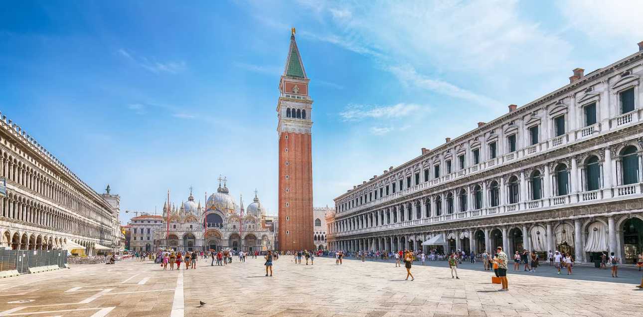
Navigating the Final Destination: Piazza San Marco
Once your feet bring you into the grand square, understanding the spatial layout ensures you arrive safely at the entrance of the Basilica without getting turned around.
The Main Square (Piazza): The long, rectangular main courtyard bordered by the arched arcades of the Procuratie. As you face the Basilica, the historical cafes Quadri sits on your left and Florian sits on your right.
The Campanile: The massive, freestanding red-brick bell tower that rises directly in front of the Basilica. The entrance queue for the Basilica typically forms near the base of this tower, wrapping along the northern edge of the square.
The Piazzetta: The smaller, open offshoot square located to the right of the Basilica. This corridor leads past the side of the Doge’s Palace down to the waterfront promenade (Molo), marked by two massive granite columns bearing statues of St. Mark’s winged lion and St. Theodore.
Essential Safety & Cultural Tips for Pedestrians
Walking to St. Mark’s Basilica is an unforgettable cultural experience, but navigating Venice as a pedestrian carries specific responsibilities and regional hazards that every traveler should know.
The Phenomenon of Acqua Alta (High Tides)
“Acqua Alta” is the term used for the exceptional high tides that periodically flood the lowest zones of Venice, most notably Piazza San Marco. It occurs primarily during autumn and winter.
Elevated Walkways: When flooding occurs, city workers rapidly deploy networks of elevated wooden planks known as passerelle. These walkways create defined pedestrian routes across the flooded squares.
Walk in Single File: When using the passerelle, you must walk in a tight single file line. Do not stop to take selfies or photos on the walkways, as this causes massive pedestrian traffic jams behind you.
Appropriate Footwear: If the tide rises above 110 centimeters, standard shoes will fill with water. Consider packing lightweight, packable rubber boots or purchasing temporary plastic overboots from local street vendors if high tides are forecasted during your trip.
Venetian Etiquette and Public Regulations
The local municipality enforces strict laws to keep the historic center clean, respectful, and safe for residents and tourists alike. Violating these rules can result in significant financial fines from the Polizia Locale.
Do Not Sit on the Ground: It is strictly illegal to sit on the steps of monuments, bridges, wellheads, or on the pavement of Piazza San Marco to rest or eat food. If you need to rest your feet, you must use public benches found in smaller neighborhood campi or sit at a designated cafe table.
No Picnic Zones: Picnicking in public pathways or on the steps of the Basilica is prohibited. Keep all food and drink stored in your bags until you reach a park or indoor dining establishment.
Dress Code for Basilica Admission: Remember that your walk terminates at a sacred place of worship. You will be denied entry at the door if your shoulders and knees are not covered, regardless of how long you walked to get there. Backpacks and large luggage items are also forbidden inside the sanctuary; you must check them at the nearby Ateneo San Basso baggage deposit before entering the queue.
Manage Consent
To provide the best experiences, we use technologies like cookies to store and/or access device information. Consenting to these technologies will allow us to process data such as browsing behavior or unique IDs on this site. Not consenting or withdrawing consent, may adversely affect certain features and functions.
Functional
Always active
The technical storage or access is strictly necessary for the legitimate purpose of enabling the use of a specific service explicitly requested by the subscriber or user, or for the sole purpose of carrying out the transmission of a communication over an electronic communications network.
Preferences
The technical storage or access is necessary for the legitimate purpose of storing preferences that are not requested by the subscriber or user.
Statistics
The technical storage or access that is used exclusively for statistical purposes.The technical storage or access that is used exclusively for anonymous statistical purposes. Without a subpoena, voluntary compliance on the part of your Internet Service Provider, or additional records from a third party, information stored or retrieved for this purpose alone cannot usually be used to identify you.
Marketing
The technical storage or access is required to create user profiles to send advertising, or to track the user on a website or across several websites for similar marketing purposes.